5/10/18: A very lazy day. We woke up in the middle of the night to a lot of water noise smacking on the hull. We are docked bow-in toward the northeast. Wind and waves are hitting us smack in the butt from the southwest. Thankfully they are not big waves; just enough to make a lot of water noise and wibblewobble and shake the boat around while we’re tied to the dock. So the small craft advisory begins. I’m glad we already planned to stay a second night. Curl up and go back to sleep. Read more
virginia
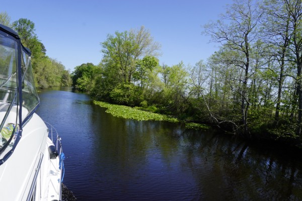
Day 58: Up the Potomac River we go!
5/9/18: As we left Crisfield, there were several large 🦀 crab sheds. Even though I still have not tried soft shell crab, I have an appreciation for the diligence that is involved in getting them to market! This was one of the huge sheds.

Crossing the Chesapeake Bay was about 15 miles of big water at this point in the bay. Lo and behold, right out in the middle, we went past this! The navigation charts said “bombing area”. This must be for target practice! The water conditions were pretty good today – we had a bit of a breeze hitting us in the starboard aft corner, so every once in awhile we’d be a little rolly. There were two large container ships that passed a couple of miles in front of us, and they left some rollers in the water. It is amazing to this Puget Sound girl that the average depth of the Chesapeake Bay is only about 20 feet. It is huge open water – much farther from shore to shore than most places in Puget Sound – but it just is not very deep. I remember in many places of Puget Sound where the depth finder just gives up giving readings because it is so deep.

Day 54: Not much exciting in Kilmarnock.
5/5/18: We got a really late start today. Being Saturday, we had to wait until 9:00 for the marina to open so that we could borrow the courtesy car to take our rental car back. Enterprise opened at 9:00 also, and they were up to their eyeballs with people! I’m sure glad we didn’t need them to give us a ride back to the marina, or we would still be there! We moved over to the fuel dock and filled with fuel, filled with water, and emptied the holding tank. 3 full tanks, 1 tank empty. Good to go! Read more
Day 53: Colonial Williamsburg
5/4/18: It was another beautiful day. We’ve had 3 days in a row in the mid 80’s! We are finally getting to wear shorts! YipYipYipee! ☀🤗 But there is still pollen EVERYWHERE WE GO!! Eternal Spring continues with us as we move north, giving us itchy eyeballs, stuffy sinuses, and yellow pollen everywhere. Today was the day that we wanted to avoid being on the water because of wind, and that was the primary reason we planned to stay here at York River for 4 nights. We spent the morning looking at weather forecasts, measuring distances to various places, and deciding where to go next. We are getting close to moving up the Potomac River to Washington DC, and we know we need reservations for the marina up there. We made a general plan for the next 10 days, and made reservations for tomorrow night and for the marina in DC. AND – we were able to extend our rental car for another day. YAY! It was time to head out for more history lessons! Today we decided to go check out Colonial Williamsburg. It is a restored 18th century town where you are immersed into life of that time. To get there, we drove on the Colonial Parkway. This is a 22 mile scenic drive that connects Yorktown, Williamsburg, and Jamestown. Even the overpasses are done in brick to stay with the colonial theme!

Day 52: Road trip to Culpeper and Montpelier
5/3/18: It was about a 2.5 hour drive from Gloucester Point (pronounced “Glouster”…. I gues the extra “es” in the middle is just for decoration) to Culpeper. Gloucester Point is where our boat is. Culpeper is where our friends live. What beautiful country! Virginia has rolling green, green, GREEN hills. OK – it is spring, but everything is so green and gorgeous! And it seems that many of the homes in the country are on very large plots of land. Everything is spacious and lovely! I do have to admit that my navigation skills at 35, 40, 70 mph are very rusty. I had to tell the Captain to make a few U-turns on our journey. 😉 What can I say?! I’ve gotten used to traveling life at 8mph. Turns and off ramps come so much faster on land than on the water!

Day 51: Declaration does not equal Independence
5/2/18: Today we rented a car from Enterprise. They offer discounts to AGLCA members, and they are great because they will pick us up to get the car! Although to save some time, the marina suggested we take the marina courtesy car up to Gloucester (about 10 miles away) to get the car. We did, and then we went over to Yorktown to the Colonial National Historical Park. We checked out the visitor center, and watched a short movie about the battle that took place here in 1781. It was fascinating! I keep learning more and more about our nation’s history! I haven’t memorized or stored dates of wars in my brain. And my brain thinks in a really linear and sequential manner, so I’ve been trying to get the events in chronological order in my head. I’m thinking – the Declaration of Independence was signed in 1776. That should have been after the Revolutionary War, separating us from British rule, right? However- I have now learned that our Declaration was not necessarily recognized by Britain. The war continued. In fact, in 1781, the American War of Independence was in its seventh year. By this time, Britain had pretty much given up on the northern states, but they were still trying to not lose the south. They believed if they could subdue Virginia, the rest of the south would return to British allegiance.

Day 50: Which way do we go?
5/1/18: For the last 1250 miles, we have had a path to follow, a direction to go, a stay-between-the-lines route to get us this far. We did have to make a choice once, weather to go left to the Dismal Swamp, or right up the Virginia Cut. Both routes converged just south of Norfolk/Portsmouth, and then we were on the main road again. Until mile O. Now, which way do we go? It’s kind of like going to Disneyland. You follow the road that takes you there, and follow directions for parking, and get in line to go in. Everything makes sense for getting to the destination. But then when you go through the front gate, there are SO MANY CHOICES! Which way do you go, and where do you spend your time? That is what the Chesapeake Bay is like. We came in the South Gate, and now – where do we go, and where do we spend our time? One could just “stay on the road”, go north 200 miles, and make overnight stops to get to the north end in just a few days. But that would be like not riding the Matterhorn or Space Mountain or Big Thunder Mountain Railroad. Why would you do that? There is so much here, we could spend all summer! We need to narrow the choices and take some tasty bites of the Chesapeake. We can always come back and explore more, right? Read more

Day 49: Portsmouth & Norfolk-two sides/one river
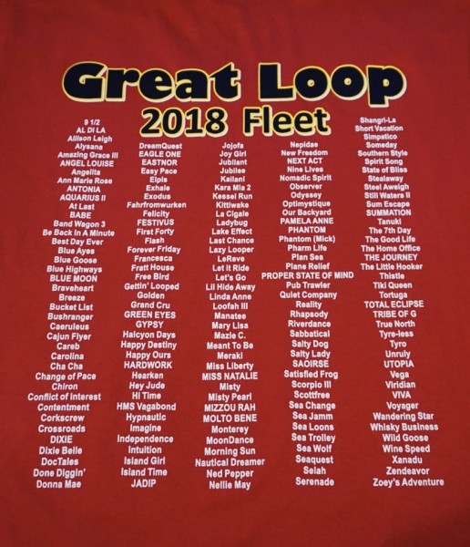
4/30/18 Monday: This looper schedule is taking over our bodies and brains! We were both awake at 5:00am. What the heck?! That ain’t natural for a Stark! I laid there until 6 and finally got up. No big schedule today, so we chilled out and had brunch around 11:00. Its a nice change to have omelets, fruit and toast at a leisurely pace. Sometime around noon we ventured out to explore historic Portsmouth. It is on the southwestern side of the Elizabeth River. Norfolk is on the opposite side. We found several looper boats here in this marina. The AGLCA Spring Renedezvous is happening today through Thursday over in Norfolk. We did not register to go to the event because we did not want to have a schedule this early in our trip. We are here just in time for it by coincidence. While here, we got our Fleet of 2018 T-shirt’s! 🤗 Yay Island Girl! See there – we are not alone out here on this adventure!
Day 48: From Swamp to City
4/29/18: Sunday: The Great Dismal Swamp. Sounds inviting? 😯 Nobody is really sure how it got its name. The swamp originally spread over 1 million acres. It was first surveyed in 1728 to run a dividing line between the disputing colonies of Virginia and North Carolina. In 1763, George Washington suggested draining the swamp and digging a canal to connect the waters of Chesapeake Bay and Albemarle Sound. He and others hoped to drain the swamp to harvest trees and use the land for farming.