We said goodbye to Bryce Canyon, and headed for our next favorite destination, Moab and Arches National Park. There were a few different routes that we could take to get there, but we chose Scenic Highway 12. We drove this last year and really enjoyed it. Check out the winding road… from the right, around, across, and curving off into the distance.
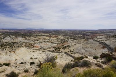
This picture just doesn’t show the drop off on BOTH sides of the road very well, but this is the “Hogback”…… steep drop offs on both sides of the road! “Between Calf Creek Recreation Area and Boulder Town is an internationally famous stretch of byway known as “The Hogback”. As the asphalt clings to this thin razorback ridge of slickrock, the terrain spills steeply off to each side toward winding creeks and canyons below.” Utah Scenic Byway 12

There is lots of open range along this road, where you may just have to share the road with a cow or two. Going up into the hills, we reached 9,000′ or so. Lots of fall colors starting to show off their beauty.

And then there are the hundreds of miles of juniper trees. I think of them as small yard landscape plants, that sometimes grow out of control. But here, they are the FOREST! Don’t leave your junipers unattended!

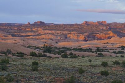
We hopped on I-70 for a few miles. Utah just has the best scenery! Giant walls jut up out of the earth everywhere.

This looks like the interstate just gets swallowed up.

And don’t be thinking all of Utah’s rocks are red or white or yellow. How about some green?

Since we were approaching Moab from the north, we arrived at Arches National Park before the town. But it was getting late in the day, and it’s quite a drive up into the park. We were planning to do some great hikes tomorrow, and we’re staying in Moab for two nights, so we just went to our little motel. Nothing fancy, but maybe the most expensive stay for the whole trip! It’s high season here after all.

It rained like crazy that night, and the next day we kept hoping the rain would go away so we could go on some great hikes. We could deal with being bundled up in sweatshirts, but we are not rainy day hikers. The forecast kept telling us that the rain would end by 12:30. Uh – it did not.

We drove into Arches National Park with hopes…. but alas…. it just kept raining. We decided not to hike. It was so cold and wet. This picture actually looks like snow, but its really just the shine from the wet on the slickrock.

The balancing rock would just have to keep balancing without us.
I think these are the ‘Three Prophets’. They are HUGE!
So! What to do in the rain? Guess what? There’s a microbrewery! We checked it out. They had great food and apparently decent beer, according to Kenny. It was a busy place, and we ate here a couple of times.

It really rained. Even the locals said it was wholelotta rain.

Still too wet to go hiking, so we thought we might as well check out the local winery, too. It was up the Colorado river about 15 miles or so. The road winds along the river, and it had been closed earlier due to slides. Apparently this was quite the monsoon rain storm – not the norm around here! There was still mud all over the road, but we found the winery.
They have a horseman’s type Red Cliffs Lodge there, with a Museum of Film and Western Heritage. Its setting is at the base of this very famous rock which is in so many movies. The museum was interesting, and we were amazed at all of the movies that have been filmed in the Moab area. It is quite picturesque!

There was no good time for hiking, but the weather did look to clear up later in the day, so we booked a sunset offroad adventure with The Moab Cowboy. Oh man was this fun! Cold, but fun! And the rain did stop, so we had some mud and puddles.

His motto was to go slow and be safe. Perfect! And if we did good getting past the first rock out of the parking lot, we’d be fine. There was only the leader and three of us vehicles following, which was great not to have a big group. And here is the first rock. Yes- a rounded hump like a whale back, that drops off both sides. Kenny drove, and I took lots of pictures to stay occupied!

These little Kawasaki’s just crawled all over the place with no problem.
We were on national recreation land. There was a display where we stopped to see dinosaur tracks. These are hard indents in the rock, and there were several of them. Hard to say that they aren’t.

Here is a trail map. There were drop offs everywhere. We saw mountain bikes, motorcycles, all kinds of off road vehicles. You could fall off a rock so easy here! I just had visions of my sons on their dirt bikes sailing off the edge of a rock into a canyon! AGH!

But the scenery and views were beautiful. And look at the blue sky!!

This is looking downstream over the Colorado river as it winds toward Moab. The road snakes along the left bank. It is a beautiful drive along the river.

These little buggies have good grip! (Thank goodness!)

Yep – we need to go up the face of this, up to where our leader is.

This shows the commonly used road along the rocks- (the black stripe). And yes – that “road” ahead is pretty much straight up!

This is why we booked a sunset adventure. It was cloudy most of the time, but we were blessed with a beautiful sunset!

And as the sun set to the west, this is the scene looking north toward Arches National Park.
Just Gorgeous.
And then we drive and crawl and climb our way out. We were the buggy behind the leader, so we didn’t have wet slippery rocks. But buggies 3 & 4 had to deal with all the water we left on the rocks, so they had a little more adventure than we did!

We had a really, really fun time. I highly recommend doing an off road adventure in Moab. There is so much public land available for exploration! Now we know – there is far more to this place than just Arches National Park. The weather changed what we had planned (like it does sometimes), and we found a great adventure waiting for us! So, don’t be discouraged when plans get changed… there’s more fun waiting if you go find it!
Here is our map to Moab.