7/31/18: I just realized when I typed Day 141…. we have been on this crazy adventure for 20 weeks already! We are more than half way around the loop, timewise anyway, as our plan is for about 37 weeks total. Dude. That’s kinda wild!
Our plan for today was to backtrack to a couple of the most popular and beautiful places to drop an anchor for a stay. Like I said before, we had really hoped to go to these with Rick & Rocky, but time and weather didn’t permit. So today we were going to backtrack from Little Current to Baie Fine. It is a long fjord bay, with high white quartz hills on both sides. I read somewhere that it is one of the largest freshwater fjords in the world. It is nine miles long, the last two miles are very narrow, ending at what is called “The Pool”.
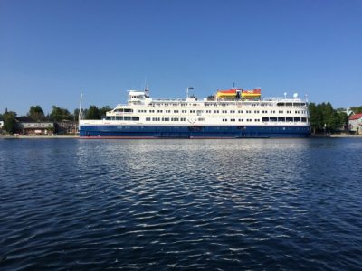
It looked like an excellent day to leave Little Current. There was a cruise ship on the town wall! Time to get outta Dodge! This ought to about double the population in this little town!
We checked the little red boat buoy to see which way the current was running. This place has current that switches direction, just like it is tidal. I didn’t think that there was a lunar tide effect in the Great Lakes, but this narrow piece of water that flows between Georgian Bay and the North Channel can run up to 4 knots, and it actually does switch a couple times a day! One of the buoys here in the harbor indicates which way the current is flowing with a boat shaped bottom!

We headed out back east, and caught the 9:00 bridge opening.

The water today was amazingly calm! What a beautiful day at sea, sir! This is my kind of water!

It was only about 24 miles to Baie Fine (pronounced Bay Fin). Actually, only about 15 to the entrance of the bay.

A popular anchorage is at MaryAnne cove, just inside the bay. Yep – there were several boats in there. We were here early, so some of these might still be leaving today. But we wanted to go the entire distance of this fjord and see it all, so we did not investigate this one any further.

We saw a boat named Shannon go by, so I had to snap it for our daughter by that name. She still has our 1987- 19 foot cuddy Bayliner. I suppose she’ll be asking for an upgrade to this Bayliner since her name is already on it.

The scenery was very different from anything we’ve seen on the loop. We haven’t seen these kinds of cliffs and so much granite and quartz. It was reminiscent of Eastern Washington near the Cascade mountains. Steep cliffs with pine and fir evergreen trees hanging on for dear life. So pretty!


Fortunately, our chart maps are good, and show where the rocks are! There were only channel markers at the very beginning of the bay. I’m glad Navionics knows how to route around this stuff!

There are some dangerously shallow places!

We got to the end of the main bay, and decided to anchor here, before going into the narrow 2 mile channel that goes to The Pool. We set the anchor down in about 30’ of water. This was way deeper than we wanted to be, but there weren’t many options. There were other boats anchored here, and we needed to be able to swing. We sat for a couple of hours watching to see if the anchor was set. It didn’t quite feel right, the wind was getting gustier, but we seemed to be ok. Captain set the anchor alarm on his phone and watched it for awhile. It is supposed to call my phone if the boat moves too far, but we didn’t have cell service this far out in the boonies, so that wasn’t really going to help if we needed to be alerted. But, he said we could go take Stuart to “The Pool”, and we could hike up to Topaz Lake, which was something I really wanted to do. So we saddled up and took a ride. This was the dock in The Pool, where we could catch the trail. There were several boats anchored in The Pool. We had been told that it was a very weedy bottom here, so not only was the holding not very good, but we’d bring up piles of salad with the chain and anchor. These are the reasons that we stayed out in the main bay.

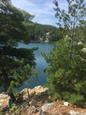
We docked, tied up, started our hike up the “trail”, which turned out to be a gully wash bed. It was pretty steep up, and rocky. I’m so thankful that my knee and ankle were doing OK with this activity! Just follow the blue markers on the trees for the right trail (we think!). As we got farther up, the trail got narrower, and almost hard to find.


We made it, and it was spectacular. It was a beautiful clear alpine lake, similar to what we would see in the Cascade mountains back home in Washington State. Of course, the Captain wasn’t into doing a selfie with me.

So I got that back of his head.

There were quite a few people up there swimming in the lake. They didn’t scream from the cold temperature when they dove in, and they said it felt more buoyant than ‘normal’ fresh water. There is some kind of mineral in the water, so maybe that is true. I wore my swimsuit and brought towels, but when I saw the steep access down to the water, I wasn’t sure I wanted to climb down the rocks to go swimming. I don’t really trust my injured knee and ankle yet. So, I didn’t swim, but that’s OK. I won’t have to hike back to the dinghy all soaking wet.

It really was very beautiful.
We hiked back down the mountain to Stuart, and went back out the channel to Island Girl. The anchor alarm said that she had moved some. We sat and watched for awhile, and I swam… correction… floated around for a little while. Kenny checked the surface temperature and it was 74 degrees. YAY! That’s 5 degrees warmer than what we’ve been in recently! The wind gusts were really picking up. Island Girl really dances in the wind, and she was wagging back and forth a lot. I was tied to one corner of her stern, and I was getting whipped back and forth like an inner tube ride!

It was getting to be about 4:00, and Captain wasn’t happy with the anchor. So we pulled it up, repositioned, and tried to reset it. Nope – it kept dragging. And the water was just too deep to get a good angle on the pull. So, we packed up and went just inside the channel that goes to The Pool. We scoped out two spots that looked good while we were in there in Stuart. So we motored in to a little cove on the starboard side. We saw several little covelets like this on the starboard side where other boats were anchored with their sterns tied to shore. It was very sheltered from the wind, and deep enough that we could get fairly close to shore. We dropped the anchor in about 20 feet of water, and it finally grabbed. Still deeper water than we like, but we would tie to shore, so we wouldn’t constantly be swinging and working the anchor and chain. We weren’t sure if this was a weedy, rocky, or clay bottom, so we were really happy when it grabbed. Then we backed the stern toward shore. Kenny hopped in Stuart and took a line to shore to tie around a tree, while I held Island Girl in position. We got her all set up and it was so nice! The wind was calm, and we were in a perfect spot all by ourselves. It was getting too late to swim, so I was looking forward to a nice dip in the morning, and maybe staying another night, since we were all nice and secure finally. This was part of our view.

Our little anchorage cove was so pretty!

Without Rick on board, Kenny was back to grilling duty!

After dinner, we sat up on the fly bridge and just enjoyed the scenery, listening to some Kenny Cheney. Our entertainment was this flat tail beaver. We saw this little face swimming across the cove. Then it blooped under the water, and came back up, and kept swimming. I got out my super fancy binocs, and figured out that it was a beaver. He just sat on the rocks, munching away on his salad. Then he went out, dove down and got some more, and back to the rock. The simple pleasures of nature’s entertainment!


We watched the sun fall behind the hill, then light up the clouds with color. What a great spot!

I’m so glad we moved and reset the anchor in this spot. It was secure and calm. We would be protected from wind, no matter which direction it came from. Ahh – a good sleep tonight!
Beautiful spot. We weren’t able to go there. What is the current smoke situation. Are you completely out of it?
We went to Little Current, and not much there. Now the wind has shifted back to a westerly, so the smoke is blowing back east toward the fires.