Wednesday: Today’s adventure took us through the Great Smoky Mountains National Park. We’ve never been here before, so I determined our itinerary to get home from Kentucky by going through the park. I hopped out and walked down the street to Starbucks for coffee to go. I was sure there would be a line outside at 8:00 in the morning. But NO! There was ONE person that went in before me. That was it!! I thought it would be busy, because I figured most hotels were like ours, and no longer serving breakfast because of Covid. Huh! Maybe everyone went to the sit-down pancake joints?
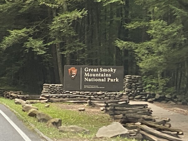
We talked for about 30 seconds about taking the scenic Roaring Fork Motor Nature Trail. That’s the one-way scenic drive that would drop us back at the beginning of town in Gatlinburg. We decided not to take the time, since reports that I read were that the park is busiest between 10-6. So let’s get there before the hoards. We passed this sign at 8:50. The Visitor’s Center wasn’t open yet (9:00), so I grabbed a map, and away we went.
Get ready for lots of pictures of hills and trees. 😀. The drive was really pretty under a canopy of leafy trees that were not yet changing clothes for fall.

This was one of our first lookout pull-outs – looking back at the road where we’d just been.
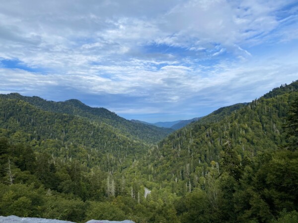

As we got higher, we could see more and more hills in the distance. The park covers more than 522,000 acres, and is the most visited national park in the United States. (wikipedia says over 12,500,000 in 2019!!)

Just a few things were starting to show some fall color.

There were still a lot of flowers, and my iphone camera on the portrait setting takes some really pretty pictures!


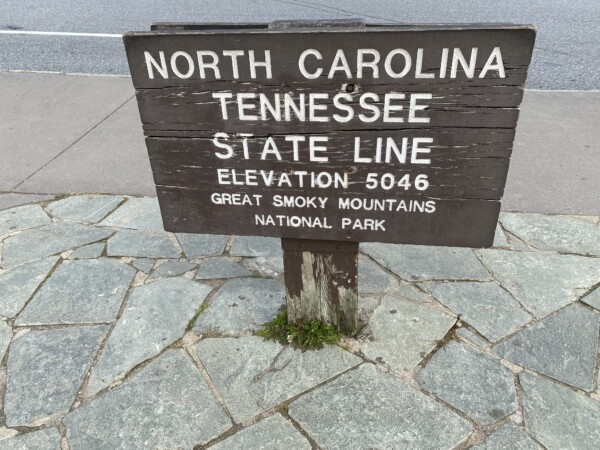
The park is divided almost equally between Tennessee and North Carolina. So this is our “welcome to NC sign”. 😉
The park also boasts about 72 miles of the Great 2180-mile Appalachian Trail that runs from Georgia to Maine. And guess what? We … did not hike on it.

This was part of the trail at one of the over-looks that we stopped at.

And this was a monument there that I thought looked cool.

I did not know – until I read this – that The SMNP is actually designated as a WORLD Heritage Site!

More pretty flowers as the foreground for some hills that just go on and on. I liked the low clouds off the the distant valley.

We made it to the highest spot you can drive to in the park by taking the side road up to Clingman’s Dome. At the parking lot, we were at about 6300’ in elevation.

The views were beautiful in all directions.

And somehow, (certainly not Kenny’s idea!) we started up this paved trail to the Clingman’s Dome Lookout Tower. Uh Oh! I was in trouble. Really in trouble. If the trail didn’t kill us, I’d be lucky if Kenny let me survive. He does not like trials with elevation change. 😳

There were a lot of people our age and older and in worse shape hiking up this trail, so we kept going. Kenny said I shamed him into it by telling him that he could sit and wait for me. But we made it! With a lot of rest stops. It was brutal.
This is the Clingman’s Dome Tower! It does a pig tail curlyque, so we had a little farther to go – we weren’t to the highest point yet.


Here was part of the view from the top.

NOW we were at the very top. And this is how Kenny felt about it. 😳. And here is why: (he doesn’t know this yet)….
Clingman’s Dome Tower is the highest point in the Smoky Mountains National Park, at 6,643’. (He knew we were above 5,000’, because breathing wasn’t easy.). The half-mile trail to the summit is paved, but very steep. The elevation went up was 332 feet, which makes the CLIMB gradient almost 13%! YIKES! Sorry honey! 😘. At least the weather was perfect… about 55 degrees and kind of cloudy. That helped, right? And you can add it to your resume, along with your 5-star side-x-side driver certification from Moab. 😁

We were above the tree line in the tower, so as we started down, we went back down into the forest. I don’t know what kind of evergreen trees these are, but they had very short needles.

Oh! And this! We actually did “hike” on the Appalachian Trail for about ten yards. This is the highest elevation of the Appalachian Trail in all of it’s 2180 miles. So there! More for the resume.

This pic was after we were part of the way down, and you can see a little paved spot off in the distance on the right? That’s the parking lot.

There was a little gift shop there at the parking lot, so I bought a little Smoky Mountains National Park Christmas tree ornament … of Clingman’s Tower. We conquered it, didn’t want a T-shirt… so got a little souvenir of something significant to us in the National Park. Then we hopped back into Mr. Lincoln, and drove on through the rest of the park. The only wildlife that we saw were a few turkeys. No – real ones. Like you eat at Thanksgiving. 🦃
At the Southern side of the park was the Oconaluftee Visitor Center and Mountain Farm Museum. We stopped because I needed a bathroom break. Then I took a quick walk down into the Farm. As I walked along, I heard several elk bugling!! And they were not very far away, in a couple of different directions! That was cool. And there were signs on this field that said “Field closed if elk are present”.

This was the Apple House, and nearby was a fenced in area with a bunch of apple trees. I should have taken a picture of the sign on the gate. It was something like – Please close the gate. You are welcome in the orchard, but the elk are not.

I didn’t read any of the history about this, because Kenny was in the truck and I didn’t tell him I was going to go down here. And there was no cell service to call or text him to tell him why I was taking so long in the bathroom. So I tried to go fast through just a small part of it. This was a neat old house!

It was a really pretty setting, right on this creek. We followed this creek for awhile on our drive down. It was the only water we saw in the park. There must be more creeks and maybe waterfalls somewhere in the 522,000 acres? Maybe just not in the small part that we saw.

So – out of the park, and then a whole bunch of country and county roads to g0 about 170 miles to our friends house in Greensboro Georgia, just east of Atlanta. We saw a lot of this creeping “whack-it-back” that Kenny calls it. It is crazier than ivy – it climbs and buries everything in it’s path!

Some roads were nearly deserted.

Back when we crossed the crest of the Smokey Mountains, we entered North Carolina. Now, just 65 miles later, we’re dropping into Georgia. This was the best sign that we got…. welcome to North Georgia? Like that’s a state? Like North Carolina? 🧐

Yep – we in the South. Never tried boiled peanuts before, but they fo-sho be a thang here, y’all! We saw lots of signs for them.

This was a cute little old gas station is some random tiny little town.

We made it to Greensboro, to our friends house on Lake Oconee, but I didn’t take any pictures. 🙁. We met Sherry and Alan back in 2017 when we were first thinking about doing America’s Great Loop in our boat. We and they both did the Loop in 2018, and we became great friends. It was so good to see them, and they were so gracious to host us for the night on our way through Georgia. We always laugh a lot when we’re with them, and Sherry and I gave each other some much needed huggin’!
Tomorrow we’ll be home! We’ve been gone over five weeks, and we’re both ready to be home. And it looks like fall may be coming! Temperatures are going to stay below 90 pretty soon! YAY!😉