Tuesday, March 23, 2021.
Weather: Temp: 77/58, Humidity: 94/39%, Top Wind: E-11 mph, Precip: None, Miles Traveled: 55
*********************
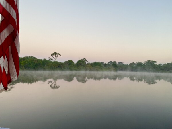
Last night we agreed with Beachside that we wanted to go through the lock at the same time. It’s an 8’ drop, so it just makes sense to time it together, otherwise someone would likely have to wait awhile. We’ll drop lines sometime around 8:00. Sunrise is around 7:30. And wow – it was dew point when I got up at 7:00! Here is the view out the back of the boat. A little bit of steam rising from the flat surface of the river made for a beautifully peaceful setting! There was no breeze, and not too cold.
The dew was heavy and everything outside was dripping wet. I went out and used the squeegee on the windows in the fly bridge. HA! What a wasted effort! As soon as I did it, they were fogged over immediately. 🤷♀️😠 At least Kenny’s window was already open, so he’d be able to see forward. It was still too cold to roll the rest of the windows up. Afterall, they are new, and to roll them when they’re cold takes a chance that they’ll crack. So I just kept wiping and squeegeeing.
Beachside Tom called the lock, and we were told by the lock tender to drop lines and be ready. So we did…. and then had to sit and wait for the lock chamber to fill with water. That took awhile, so we got to float around while I kept wiping windows.

Here’s looking back at the docks.

After about 20 minutes we were finally in the lock. The lock tender tossed me a line for the bow, and I started to take it to our center-forward cleat to loop around and hold. He said “NO! Take it to that forward one.” I though… WHAT?! NO!! That’s what dorks do and then things go all wonky and I look like a dweeb. But, being the crazy compliant person that I am, I followed instructions. I figured, well-it’s his lock, we’re going down so there won’t be turbulence… he probably knows what he is talking about? But I was ready to move it if things got dicey! I didn’t want to be the subject of this months lock article of “lock-through dumb-bunnies”.

Here is the view from the bow looking down the river over the lock gates.

The way they lower the level inside the lock is by just opening the doors a little bit to let water fall out. The lock line that you hold is fastened to the top of the lock wall, and just goes around the cleat to help hold the boat, but it is NOT tied off, and you hold the end of the rope. As the water goes down, you have to let out more line on the rope that you’re holding. We had a very smooth ride down, and there wasn’t any noticeable current inside the lock at all.

I could see when we were just about level with the water outside the lock. And you know what? The forward cleat worked just fine this time! So there ya go- sometimes it’s OK to listen to the lock master. (Actually, it’s ALWAYS advisable to listen to the lock master!)

We were out of the lock about 15 minutes later and on our way east. We needed to curve our way around Stuart and go out to the “Crossroads”, where the Okeechobee Waterway and the Atlantic Intracoastal Waterway intersect and then we would head north. Before we got to that point, there was a 14’ bridge that we needed to have opened. And as we were about a half mile away from it, we realized that it only opens on the hour and half hour. Dangit! That was a lack of planning on the navigator’s part! 😳 It was 9:29. AGH! It wasn’t open yet and we thought for sure we were going to have to tread water for half and hour. Then we heard another boat call the bridge. They were pulling out of a marina right in front of us to get to the bridge for the 9:30 opening, which actually gave us a little more time to get there. We called the bridge tender, and thankfully she kept the bridge open for us and we passed under it at 9:37. It always sucks that there always seems to be a mile of no-wake zone before the bridge that you’re trying to hurry up and get to! That probably makes the people on the highway really mad because the boats are just puttering along, looking like they don’t care that they’re creating a traffic jam. Our friends on Beachside were maybe a quarter of a mile behind us, and the bridge tender said she couldn’t hold it open for them, so we lost them here. Bummer.
About an hour later, we made it to the famous “Crossroads”. The last time we were here it must have been a weekend, which we said we would NOT EVER do again. It was crazy mad traffic zipping around in every direction at high speed. There is a channel out into the Atlantic here, so there really is four way traffic. But today…. there was nobody but us and the boat that went under the bridge before us! This marker is where we turned left to go north…a change in direction for the next three months! It’s 988 miles to Norfolk Virginia from here, where the AICW ends and Chesapeake Bay begins.

This is our route today. At the bottom left you can see where we had to loop around Stuart to get to the crossroads to turn north.

Here is looking out at the Atlantic at the crossroads. It was rough out there! We could see breakers splashing!

And here we go north! The water was calm, a bit of a breeze that kept trying to blow us out of the channel. Captain had to keep pointing the boat about 6 degrees farther to the west than we wanted to go to compensate for the breeze in order to stay in the channel.

We passed several little islands here in the waterway. This one looked so peaceful and pretty with that beach!

The water is a pretty color here, near the inlets to the ocean. Kenny’s eyes are on the water all the time and he saw a couple of rays leap out of the water. I missed them. 🙁

About 55 miles and six hours later, we arrived at the channel into the Loggerhead Vero Marina. We stayed here in 2018 and enjoyed it, so thought we’d stop in again. It’s in a nice protected basin, but a long channel only really wide enough for one boat.

And here is one reason this navigator chose to stop here on this fine sunny day. A beautiful pool! But you have to be part polar bear to swim in it. I put my feet in and it was chilly! 🥶

After a little relaxation at the pool, we went back to the boat for some chores. We pulled up the flooring in the cockpit, and what to our wondering eyes should appear, but black bug splats everywhere! Eeeew! I told you that those freeloaders were everywhere! So we got out the scrub brush and cleaner and swabbed the deck and the flooring mats.

We ate dinner outside in the cockpit again on this beautifully comfortable evening. Then we went inside and caught up a bit on the weather and trip logs and blogs, and set about finding a new coffee maker in Amazon. I don’t know why, but we seem to burn through them! The one we have is barely dripping. We tried running vinegar through it, but that didn’t help. AHG! MAYDAY, MAYDAY! Starting our mornings without some good mojo juice will not be good for this crew. Ah-ha! Success! We can get a rocket fuel injector delivered by Thursday to Cocoa Village Marina. Sweet deal, since we plan to be there for at least two nights. It’s a fun little town, and we’re headed there tomorrow.

We’re both looking forward to staying in one spot for a couple-three nights. By the time we get to Cocoa Village tomorrow, we’ll have over 300 miles behind us in just 5 days. They haven’t been terrible long days or bad weather. It’s just been non-stop, so it’s time for some relaxation in this “pleasure boating” adventure! 😉
Glad you made it to the East Coast.
We live in New Jersey, near Atlantic Highlands. I picked up your Blog via the BOC on your last trip. We have boated from Nantucket to Norfolk and to Lake Champlain. Over the years four of our eight boats have been Bayliners 28, 32 38 and our last (sold last year) an Avanti 40. We kept the Avanti in the Chesapeake on Kent Island for the last 14 years.
Keep up the great travelogue…
Walt