Thursday May 13, 2021.
Temp: 67/47, Humidity: 32/86%, Top Wind: NE13mph, Precip-none, Miles Traveled: 14
*********************
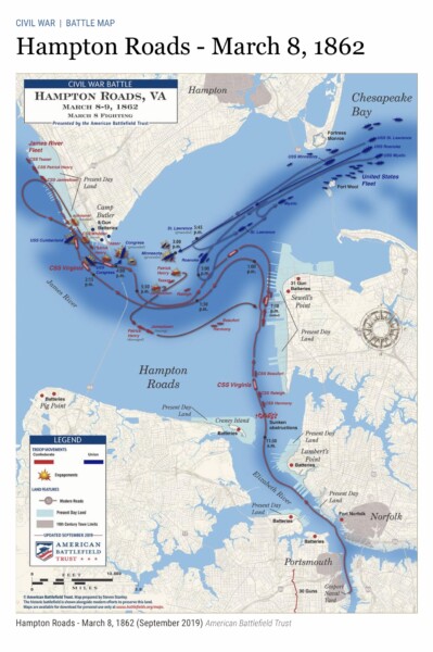
This geographical area of the southern end of the Chesapeake Bay is known as Hampton Roads. It has had this description for hundreds of years. In fact, here is a civil war map of a historic battle between Union and Confederate ships in 1862. At the top of the map is Hampton where we are headed today, where the rivers flow out to the right into the Chesapeake Bay. At the bottom right is Norfolk and Portsmouth on the Elizabeth river, where we are now. On the top left is Newport News on the James River.
The term ‘Hampton Roads’ is a centuries-old reference that originated when the region was a struggling British outpost nearly 400 years ago. Designated in the 17th century as the name of the largest natural harbor where the James, Nansemond and Elizabeth Rivers pour into the mouth of the Chesapeake Bay. Signifying the safety of a port, “roads” in nautical terminology means “a place less sheltered than a harbor where ships may ride at anchor”.
We pulled our lines around 10:00 for our short trip to Hampton. Good-day to you, Norfolk! It’s a pretty nice day out here, with just a light wind and only boat waves. YAHOO!

The USS Wisconsin looks kind of funny from the water, tucked in among the buildings. Oh look! There is one of the American Cruise Lines ships that does cruises around the Chesapeake Bay.

We headed out of town, and I tried to get some pictures of some various ships. They are everywhere. There are cargo ships, navy ships, merchant ships, ship building, ship repairing, you name it, they do it here.

And then a big Evergreen freighter slid on past us. The photo makes it look smaller and farther away than it was, and notice how small those 40’ containers look. And it wasn’t very far away, because we were both IN the channel.

More ships. The aircraft carrier USS Gerald R Ford #78 is over there. She is the worlds largest carrier, formally commissioned in 2017, and scheduled for her first deployment in 2022. She was built right here in Hampton Roads at Newport News.

We had some crab pots to dodge, but for the most part it was a nice easy stroll over to Hampton. This is entering the waterway into the small Hampton harbor. There are a few marinas here, and we tootled on in to the Downtown Docks.

We got all tied up, which was a little bit intesting because the finger piers are short, and there is no piling in-between us and the slip to our port side. There was nothing to tie her port bow to, so Island Girl kept wanting to sit crooked with her starboard bow right on the piling. We finally just ran a line from her port stern straight back to the dock, and that helped to keep her straight.

It was only noon, so we walked into town to find some lunch. A place called Brown Chicken Brown Cow sounded like fun. We looked at their menu on-line, and they had a good assortment of yumminess. And beer. 😉🍺. It is on Queens Way, which has been blocked off for outside dining. That’s kind of a cool thing that came out of the Covid pandemic, don’t you think?

And there it is. You could miss it if you weren’t looking for it.

Since I’m not a beer aficianado, I searched for a different option. They had a locally made cider that was apple, pineapple, and basil, but I just wasn’t sure about that. So I opted for …. a creamsicle. OOOOOH baby! It was dessert in a big cup… an adult orange soda float with orange liqueur, Licor 43, orange soda and vanilla ice cream. It was excellent!

Kenny had cholesterol on a plate. The waitress even asked if he had life insurance. It was the three pigs sandwich, with pulled pork, sausage, bacon, and a bunch of other stuff. AND loaded waffle fries with beer cheese on top. 😳 Seriously. He could not eat it all. I had a spinach and chicken salad that was really yummy with a blueberry vinaigrette, and I couldn’t eat all of it, either.

On our waddle back home, we passed the First United Methodist Church. The existing sanctuary was errected here in 1887. I always wish I could go inside and see the windows, but most church buildings are locked.


Right next door was this impressive United States Post Office building. There was a sign nearby that said it is an event center, used for events such as weddings, etc. now.

It was just a few blocks back to the marina, which is one long floating dock with finger piers at the base of this promenade.

Down just past Island Girl are the outside tables for the Bull Island Brewing Company. We’ll have to scope it out later when we have more room in our bellies! Like tomorrow?

I took this picture just to get an idea of the elevations of everything on the top of the Girl. We need to be as short as possible to go through the western end of the Erie Canal. The lowest bridge is 15.6’, and we are currently 16’ to the top of the radar (ignoring antennas and the anchor light that can lay back). Anyway, this is just a visual for the Engineer’s planning purposes. 🧐

Here’s another shot showing the outside tables at Bull Island Brewing.

We were so full from lunch, we conked out for a nap, and didn’t need any dinner. It’s nice to be docked in a place where there isn’t a bunch of water traffic, waves or wind! It is much quieter here compared to Norfolk. We don’t have all the industrial noise here, but we do get a honking horn every once in awhile in the parking garage above the brewery. 🙄. It’s only Thursday…. I wonder if there will be live music tomorrow?