Monday May 31, 2021.
Temp: 72/48, Humidity: 42/94%, Top Wind: NW12mph, Precip-none, Miles Traveled: 58
************************
Today we finally got to leave Annapolis! The weather hawk that I’ve been says – it’s time to go! Based on the currents in the upper Chesapeake, we postponed our departure until about 9:00, so that we would have current in our favor instead of fighting it. My goal was really to get to our destination around slack tide, yet I wasn’t totally successful with that. But all is good, and we are rocking out to live reggae music this evening, with the band close enough to hit them with a marshmallow. 😆. However, internet and cellular service are not good and I cannot get pictures to load, so I’ll have to write this tomorrow sometime.
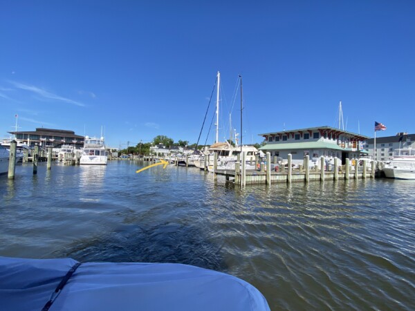
This was departure from Annapolis. The yellow arrow is pointing to where we’ve been sitting. All the waves and wakes from ‘out here’ roll in ’right there‘.
This is looking just to the west towards town, and that little channel where the sailboat is headed is known as Ego Alley. That’s where you can cruise your boat down into town, turn around, and come back out – mostly just to show off. We’ve seen big yachts, go-fast cigar boats, dinghys, paddleboards, and anything that floats make their way down and around.

This is looking back at the marina, through the big mooring field. Annapolis is one busy harbor, and probably the sailing capital of the Chesapeake Bay.

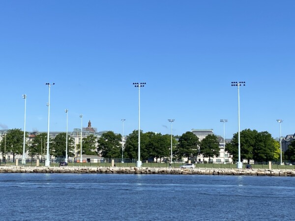
On the west side of the harbor is this big giant field which is part of the Naval Academy campus. The whole area is bigger than several football fields!
Out on the bay, we dodged a few sailboats. Afterall, this is Monday of Memorial Day weekend, and the wind, cold, and rain finally subsided enough that there were lots of boats on the water today. Looking ahead is the Bay Bridge. I only captured a piece of it, but it is actually over four miles long!!

Here is looking west from the center. It is the closest and most direct route to the Delmarva penninsula from the greater Baltimore/Washington DC metropolis area.

As I said, there were a lot of boats out today, and lots of loopers who were tired of being held captive by the weather! This is NEBO, which shows some of our looper boats. There was a lot of activity, finally!

It was a bit choppy and chilly, so I sat in the sunshine to try to keep warm. The wind was from the northwest, and we were headed north, northeast – so it was blowing through and keeping us from overheating, that’s for sure!

At one point, Captain decided to go fast for just a bit to try to get in front of a big barge that was making it’s way up the Bay. We didn’t want to get stuck behind it when the waterway got more narrow. Look at that! Cruising over 21mph!

But that was nothin! We were left in the dust by at least a dozen go-fast boats, doing what they do best – going fast, making waves, and these kind were really loud! They were all bunched together, so we figured they must have been doing a poker run or something.

We had lots and lots of wakes to jostle through for a while!

The top of Chesapeake Bay narrows down quite a bit, and we headed to the northeast section where the Elk River flows in. This is the Turkey Point Light Station. It was placed in service in 1833 and was automated in 1947. Prior to automation, lighthouse keepers would haul a copper kettle filled with kerosene up the thirty-one stairs of the lighthouse and up the iron ship’s ladder that led to the lantern – four times a night, just to keep the light on all night.

Most of the scenery on both sides of us was woodsy, until we saw this! It is a huge RV resort!

There were dozens of golf carts parked at the beach, with people and umbrellas planted in front of them. Maybe they were having a huge community picnic or something.

We turned east into the C&D Canal (Chesapeake & Delaware). It is a 14 mile long man-made canal that connects the north end of the two bays. It was dug way back in the 1820’s and is one of few fully sea-level canals in the world. When it was used back then, there were locks to help manage the swift water flow. However nowdays, there are no locks and the current rips through here in both directions with the tides of the bays – sometimes more than 2.5 mph. THIS is the current that I was trying to time for slack after high tide. Slack lasts for about 4.3 seconds, and then somebody lets the plug out of the bathtub on the other end and it runs the other direction like a raging river.
And just take a wild guess on where all the go-fast boats went!? Yep. Right here at Schaefers Canal house, restaurant & marina – our destination. We planned to get fuel here since it’s the cheapest around for at least 100 miles, then spend the night. There was another boat waiting for fuel and his slip for the night too, so we just had to point into the current and tread water for about 20 minutes and wait.! Sheesh! This is where we sat “in line” and waited. The fuel dock is to the left past the bridge pilings about where the bright green boat is. They technically were not ON the fuel dock, and were just sitting there drinking beer, without a care in the world.

We later discovered that these two boats were in our over-night spot. We also learned that the poker run was supposed to have been yesterday, and the marina did not know it was going to happen today. Waiting for dock space was us, the guy who fueled just before us, and a 100’ yacht that came in behind us – all at about the same time. The big white boat way to the right was right in front of us, and he managed to get a spot. Lucky duck.

And lets just say that go-fast boats that are on a poker run, a day late when the sun finally came out on a holiday weekend, are not in a hurry to finish their drinks and leave. We finally got to the fuel dock, and the marina had us just stay tied up there for an hour and a half, waiting for the zoomers to zoom on outta there. The big yacht had to just sit out in the canal for about an hour and wait.

The marina staff was SOOO apologetic, and so appreciative of our patience. Hey – it was not big deal as long as we could stay tied to the dock! If they had made us leave the fuel dock and tread water to wait, we might have been just a touch cranky. They finally got enough boats cleared out by about 5:00 that we could go to our spot. By now the current had switched, so we docked facing the other direction. That’s OK – our nose was pointed in the way we want to go in the morning, and the current would have switched, and then switched back again to be coming at our nose in the morning.

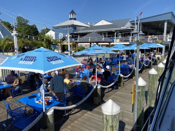
So here is our view once we got settled! There were piles of people everywhere – this is a huge restaurant!! There was live reggae music playing and we had a front row seat with the cheapest beverages of anybody!
Across the canal from us is Chesapeake City. There is a little bay there where a few boats can anchor, and another big restaurant with a lot of dock space. And I’ve heard that it’s really a cute little town. I chose this side because of the fuel, and the other side was still charging their holiday rate of $3.25/foot for Monday night. 🤷♀️ Yikes!

Here is a dark beer that happened on Island Girl, in our funny little Ooglefinch beer glass.

And yes – we got here around the slack for high tide, and now it was going out. The dock gals told us there would be about a three foot drop. YEP!! I think when we tied up, we could step straight across from the gunwale to the dock. Not now, kimosabee!! We decided to have dinner here, so we climbed up onto the dock and checked our lines so that Island Girl wouldn’t hang herself.

I didn’t find the parking lot, but there must have been a zillion cars somewhere, because there was way more people than all the 400 boats could hold.

Their deck chairs were really cool and very heavy! They are not going to blow away.

We watched Island Girl continue to sink into the sunset.

My dinner was delicious! I ordered a crab melt, which was crab imperial with tomato and swiss cheese and bacon. So good!

Kenny ordered a seafood ravioli that was out of this world amazing. The ravioli was stuffed with crab, then topped with fresh shrimp and lump crab meat and a light sauce. Oh man it was good!!! He said that it was by far the best meal he’s had on the loop and maybe even infinity and beyond. We were both amazed at how excellent the food was with such a giant restaurant.

I missed the actual setting of the sun, but the lasting effects were nice. The fuel dock is WAYYYY down there on the other side of the bridge pilings.

The bridge did make a pretty sunset evening picture. Surprisingly, the traffic on it was not loud, which was nice.

We got back to Island Girl and she was just about at the bottom of the tide. And at this point, our cellular service and wifi were just about gone.

We checked our lines a final time since we were pretty sure we were at low tide, and we notice that our neighbors lines were holding REALLY well! YIKES! They were starting to come out of the water and tip over. OOPS! But we knew it wouldn’t get any worse, so we didn’t go wake them up.

Here was the tide chart. A 3-4 foot change isn’t a big deal if you have floating docks. But it is a bit of a challenge with a fixed dock! At least we knew we were at the bottom of the ocean and we would start floating up again about 4am, then we’d start going down again. It’s just so surprising how fast it changes here.

Tomorrow we have a long day, going all the way to Cape May so that we can run up to New York on Wednesday. We’ll pray the weather forecast stays as good as it currently looks – for both days!!!