Wednesday September 8, 2021.
Temp: 83/64, Humidity: 33/91%, Top Wind: NW13 mph, Precip: None- sunny, Miles Traveled: 84 in less than 7.5 hours 🚤, Number of locks: 2, total drop of maybe 12’?… should be more like 35!
+++++++++++++++++++++++++
As planned, the annoying sound of my alarm went off at 5:45. I wasn’t ready for that. 😴. But, up and attum and get with the program. Start the coffee. Check Amazon and see if my book came. Nope. Take the key to the drop box. Come back and go upstairs to open the windows. Check the Lock queue to see if there’s anybody there. Nope. Finish coffee. Unplug, get lines ready to go. Call the lock. He says ‘call me when you’re out of the marina’. Untie, back out, tootle out, call the lock again. He says ‘come on!’. Sweet! All of that before the sunshine even showed his pretty face!
We were in and out of the lock before I got any pictures! The lock master told Captain that we could float through, but we had a bit of wind blowing up our rear, so I voted that we grab a floating bollard. Even with our normal two lines on the pin, the stern of the Girl still kicked out, and she just wanted to ride that way with her nose kissing the wall. We watched a lot of debris floating around us, and Captain said he didn’t want to use the bow thruster to get us off the wall, and that he really didn’t even want to start the engines! The lock was supposed to drop us down about 23 feet, but I think it was more like 10’.
For such a huge lock, it wasn’t long before the doors were opening! I had Kenny tie his stern line off to leave his post, otherwise we would have gone completely sideways. He started our engines, I got our lines off the pin, and ever so carefully we meandered our way through to the end of the lock. That’s where it got hairy. There were whirlpools and turbulence right beyond the gates, so moving at idle speed didn’t really control the Girl very well. Then clunk, thunk, bang, and “Awe S#!t” from the helm. Some kind of wood product got under the boat and hit hard. It wasn’t just a bonk on the side of the hull. Hopfully that didn’t twist a prop! 🥺.
There were a lot of tows parked around here, just waiting for some stuff to push around.

It was only a few more miles and we were at the entrance channel for the next lock. The Chain of Rocks lock has about a seven mile channel for an approach. Don’t go right, or you’ll be white-water rafting!

After a looong approach, we called the lock, and he said just keep her comin’! YAHOOO! No wait on either lock today!

I still had my fenders and lines on set up on the port side all ready. The wind had calmed down, and the lock tender said that he didn’t have any floating bollards on that side ☹️ so we could float down if we’d like. 👍OK!

I watched the gate close behind us. It came up from underneath! No big lock doors here on the up-stream end.

We were all by ourselves again, so we gave floating through a whirl. No sweat, Jett. And what was supposed to have been a twelve foot drop was really only about five feet, as you can see by the wet section of the walls. The down-stream gates opened way before we expected them too, and we had a nice peaceful, calm, non-eventful exit.

Within just a couple of miles, we were coming into the city of St. Louis. I quick found the link for the St Louis Arch webcam and sent it to our kids. It was only 6:30 at their houses in Washington, but most of them would be up. Somebody might be able to tune in and watch us live and in person!

I remember last time we were here, I learned all about that intricate steel bridge. It was really very interesting and unique for its time.

The Arch is waaaaaay taller than it seems, at 630’! 😮 And check this out! We got a great screen shot of us going past it! Look how tiny we are!

That was fun. There are no marinas on the Mississippi River in St Louis, so boaters have to stay out of town and either rent a car or Uber in. There is a dock for this tour boat, but that is it.

We spotted the Budweiser building, which was huge. I tried to get a good shot of all of it in one picture, but couldn’t because of the peep-a-boo through the trees.

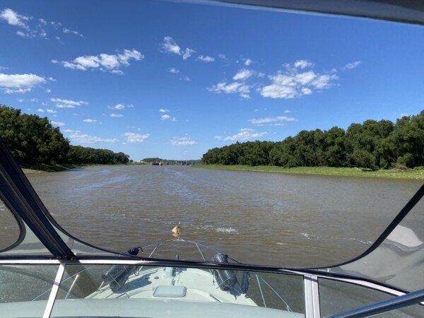
There is definitely some current in the river. We hit 13 mph at our normal cruising rpm, so that’s about a 4mph benefit. And just like that, we were through St Louis. Check out that red line we’re leaving! That means we’re going over 10mph. (Our normal color is green.)

There was a bit more industrial area, and then we were through.

In the city, the hills were topped with old apartment buildings. South of town, the hills were topped with huge homes on the Missouri side. As we travel down the river, Illinois is on the left/east, and Missouri is on the right/west.

The river widened out, and we could start to see the weirs on the edges, which are long rock jetties that push out into the river. They run all along the river, and we never saw a single one of them in 2018 because the water level was higher then. I guess they help direct water to the middle of the river and keep the banks from washing away. You definitely want to stay between the markers on this river.

Also in 2018, many of the markers were being swept under due to the swift current in the big water. This year, they’re staying above water and actually showing an eddy and the current much better!

For years, a place on the river called “Hoppies” has been a popular stop for loopers. We’ve never stopped there because it isn’t far enough down the river for us. We were here by 11:00, so we just kept on a-goin. They used to have several barges that you could tie up to, I think a restaurant, and an elderly owner lady named Fern who would give a river route briefing. After flooding in 2019, they only have one barge, and now Fern has help giving the briefings. But I heard they do still have fuel. I remember a story about someone meeting Fern, and she was out on the fuel dock smoking a cigarette. They asked her about that, and her reply was something like, Well – we all goin out sometime, might as well go out with a bang! And she kept on smokin. Hoppies is the white roof building on the left, and there was one looper boat parked there as we went by. The red roof builing on the right is suffering from low wate syndrome. It’s grounded.

I snapped some shots of some nice looking homes on the Missouri bluffs. This one was stone, and stone structures always catch my eye. I think I really need to take a trip to Tuscany Italy.

And this one was just huge, with a bit of a lodge look to it.

We met a few tows going up river. Man, they sure do churn up the water! This one had 18 barges! Three across and two deep right in front of the tow, then four across and three deep in front of that! These river captains are amazing and very friendly, since we always call and ask how they’d like us to proceed. We never know what their route or plans are, so we always ask.

This was some kind of castle. You just don’t see that every day.

The cliffs were interesting in places like this. They look like the limstone is trying to create arches!

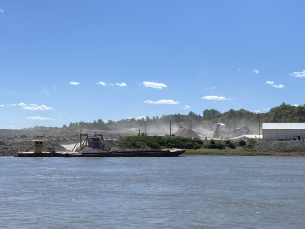
Most of the river scenery is just forest land, but every once in awhile there is some kind of industry. This was part of a huge pit, and they were making all kinds of dust.
And who doesn’t love a sandy beach!? With the water level down, there are all kinds of sandy beaches along the way. Not that you’d want to swim in this muddy water, but it’s a nice beach to hang out on.

After about eighty-five miles we made a left turn up the Kaskaskia River. There is a lock just a half mile up that has a nice long wall available for an overnight tie up.
We were the first ones here today, and had two other boats come in later. This is just a long wall that juts out along the exit way of the lock, and segregates the dam water from the lock. We are tied up on the dam side, but it didn’t look like there was any water coming through the dam. The water was very calm.

We are not allowed to leave this wall. The ony way off is to climb a big tall ladder at the end, which we don’t need to do, because there isn’t anywher to go anyway!

It was kinda toasty, with a nice breeze blowing onto our bow, so Captain hung out upstairs in the breeze for awhile.

I opened windows and doors to try to get it cooled down, but it was plenty warm inside too. At least the humidity was low!

We turned on the generator and the a/c for a bit while I made dinner, and that cooled it off nicely. The temperature outside dropped to about 65 by 7:00, so it was nice and comfy. This is where we are tonight – nice and safe off of the big river.

We’ve been debating on how far to go tomorrow. A creek called Little Diversion is 68 miles from here, and that’s where we stayed before. It was nice and safe and easy. That makes the next day 95 miles to Paducah, with half of it going down-stream on the Mississippi, and the other half going up stream on the Ohio River. That would take us about 11 hours. With the water levels high in 2018, we didn’t have to lock through the Olmsted Lock on the Ohio. But this year we do, and that can take some time. So we’ve been thinking about anchoring at a place called Boston Bar, which is 110 miles from here. With the river current, that will take us about 8.5 hours. Then we just have 53 miles the next day, which will take us about 8 hours, plus lock time at Olmsted. I texted our buddies on Dream Weaver (the one whose package we have from Alton Marina), because we saw on Nebo that they went past the Little Diversion turn off. I asked them where they planned to stay tonight. He said Boston Bar. Great! I asked him to please send me a scouting report, which he did, and he said it was good. With the river level as it is, the water is not too deep there, and there isn’t a lot of swift moving debris. OK – we’ll do it. So now we are planning to split our days into two eight-ish hour days to get from here to Paducah. Stay tuned…..
Happiest WA fun. We ate at the Blue Owl. Good pie. You are moving right along.