Thursday, September 30, 2021.
Temp: 78/68, Humidity: 72/100%, Top Wind: S5 mph, Precip: warm, humid, & rain,
Miles Traveled: 57 in 7 hours, Number of locks: 1, up 55 feet
~~~~~~~~~~~~~~~~~~~~~~~~~
Captain came upstairs this morning wearing jeans, and I told him that he was going to be uncomfortable. He looked at me funny and I told him to trust me. It was a “swim through the air“ kind of day, so he changed into his shorts. Yep – check that humidity. 😅💦. As we were getting ready to leave, we saw Dick & Louise, getting Nine Lives ready to go. They said they’d be about 20 minutes behind us. That would work out good, since even though it’s nearly 50 miles to the Pickwick Lock, it would be good to be there together. We had a really pretty sunrise with some clouds. There was a threat of rain today.
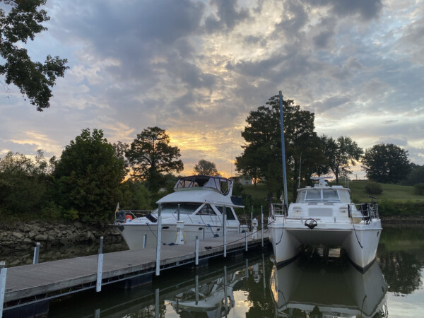
This is the marina office, store and restaurant where we are docked. Out to the left is the fuel dock. When we were here in 2018, we were placed into one of the covered slips. But today, they are all full. This marina is in a perfect stopping spot on the river, and most loopers do stop here. I don’t know what they’ll do if 20 boats come in at the same time. 😳

I went upstairs to get the windows ready. We had left the two front ones and the port side windows open, so I didn’t have to mess with those. But the rest of them were soaking wet, inside and out. I’m really thankful for my soak-it-up-shammy thing to swab down the windows with.

We were in a skinny spot between the dock and the rocky shore. We had about nine feet of depth when we came in. Take a gander at the wet rocks. It looks like the water level may have dropped a foot or so overnight? I checked the TVA lock discharge report, and the Pickwick dam discharge is way down around 25,000 this morning. I’m sure it won’t stay that low.

We tootled on out to the river and were really happy to see no sign of fog this morning. It may rain, but we’ll take rain over fog, thank you very much for asking.

We saw a huge variety of living accommodations along the river today. These were just a few of the huge beautiful homes up on top of limstone cliffs.

These were more on the “inside of the curve” which tends to have a lowere elevation. At least they still had limestone for a foundation, and they were lovely homes.

There were A LOT of these! I’m guessing to get a building permit, your permanent living quarters must be at a certain elevation. There were lots of these kinds of homes. reminding me of those we’ve seen in the Gulf communities where water can run high. These didn’t have a natural limestone foundation, but they’ve added tons (literally) of rock to shore up the bank.

We did get some rain. It came and went, came and went throughout the day. Close the windows, open the windows, repeat. It was so warm and humid that having them closed was like a steam bath, so we’d open them as soon as the rain quit.

This house was SOOOO high up in the air, I hope they have an elevator. The RV-ports were by far the most common accommodations we saw today. I’m supposing that folks purchase a chunk of land and build their RV-port for their camping getaway time? I don’t know. Do people come north to here for the summer? Where do they all come from?

The foolish man built his house upon the sand …. or upon the clay bank. This was a HUGE land slide that apparently happened quite some time ago. The remaining house up on top must be condemned? – I HOPE! Kind of surprising that it hasn’t been torn down.

More RVports, all with their exensive rock banks and stairs down to the shoreline. The rock has to be worth more than the land, don’t you think? How many truck loads does it take to rock your bank? … or break your bank? 🤔. It is not required, as we saw a lot of parcels where there was no rock, and therefore the bank has been eroding away.

This old plantation style home up in the trees was beautiful. If you look to the right of it, there is a smaller stone structure with a statue on top. We wondered if that was a family crypt. 🤔

As we traveled along, the current got stronger and stronger against us. Our route from the Grafton Marina to the Pickwick Lock was about 46 miles. We left the marina at 7:20, and by 12:20, we still had an hour to go and we were now only moving along at about 7mph. Dick and Louise had gone fast a few times to catch up with us. Dick called us on the radio when we were about 7 miles from the lock to see if we had called the lock yet. No- we had not. So he called the lock to find out what the scoop was. (The webside for the lock queue was not working this morning.) Dick called us back to let us know what the locktender said: There was currently a tow in the chamber coming down, and there was another one waiting to come down. There was a pleasure craft at the bottom waiting to go up, which he intended to lift as soon as the current downbound one was clear. If we could get there within 30 minutes, we’d make that lift, otherwise we’d have to wait for the other downbound tow to come through. So Dick asked “Do you have another gear? Can you get there in 30 minutes?”. Yep – we have another gear – let’s get moving! So we put the pedal to the metal, but with the increasing current, we could only go 17mph. 😳. That was fast enough to go the 6.5 miles in 30 minutes, but dang – it felt like we were dragging a dozen five gallon buckets behind us!

When we first floored it, we were doing 17mph. But the closer we got to the lock, the slower we went! The discharge current was really strong and getting stronger. We passed a little sailboat right when we started to go fast 7 miles ago, and it will probably take him two hours to get to the lock with this 4-4.5mph current! Nine Lives kept up with us, and we both got to the lock just as the downbound tow was clearing and the houseboat was starting to move in. There was also a sailboat that was already tootling into the lock chamber, so that made four of us taking a ride up the lock. Check this screen shot out. We still had two miles to go, and couldn’t even go 16mph. We generally go just over 20mph at this rpm.

Kenny radioed the lockmaster to see where he wanted us, and he said that he needed everybody on the port side. He only has three pins, so somebody would need to raft up. So we took the third pin after the sailboat and the houseboat, and Nine Lives rafted to us.

As we were pulling into the lock, I saw this weird dead fish. I’ve never seen one with a long pointy snout. Apparently it is a (dead) gar.

We got all secured to the pin, then Nine Lives came in and tied off to us. This is a big lock, with about a 55’ lift. Check out the size of that door closing behind us!

Here is Dick & Louise!

All of the water filling the lock came in on the starboard side, so it smashed us up against the wall. Ordinarily this is OK, and we can manage to push off a bit so that our fenders don’t have to stretch and squish too much. But with both boats pushing against the fenders, I could not fend the bow off of the wall like I usually do. Finally I asked Kenny to trade places with me. He did but he even finally sat down and pushed with his foot to get more leverage than pushing with the dock pole. There were still several times when I thought the cylinder fender at our mid-ship was going to stretch so long that the rope would pop out of it or it would pop. As we smashed against it, it squished and would stick on the rough lock wall so it couldn’t slide up with us as the water came up, so it stretched beyond what I thought it could! Good ol’ Taylor Made fenders, it didn’t fail us!

It all worked out OK, and no fenders were lost in the filming of this adventure. We were happy when we finally made it to the top, and the lock gates were opening. Everybody peeled out of the lock before us, and then we made our way out. It was about nine miles from there to the Aqua Yacht Harbor Marina where we have two nights reservation. We were getting along just fine until a rain storm decided that we needed to close our windows AGAIN! Fortunately, it let up for us as we came into the marina so we didn’t get all soaked as we tied up. But it did continue to rain all afternoon, so we just stayed inside and didn’t venture out anywhere. We have all day tomorrow, and they have a courtesy car here, so I’ll make a run to the grocery store to get some fresh food. Kenny is going to change the thermostat on the port engine. It has stuck open a couple of times, and that makes him nervous.
By the way – we are in the state of Mississippi now! We are at the top of the hill at an elevation of about 414’. Everything will be downhill from now until we reach the Gulf of Mexico. This screen shot shows where we are… just below the Tennessee/Mississipi state border. Just to the east of us, the Tennessee River is the border between Alabama to the northeast, and Mississippi to the southwest, so there is a junction of three states right here. The Tennessee River continues on to the east to Chattanooga and Knoxville. We will be following the waterway that goes south from here, called the Tennessee Tombigbee Waterway, which will take us to Mobile Alabama.
