Saturday: This was the first of two 500 mile days. Most of it would be straight and flat in Kansas. But first we had to climb the Rockies to the top! This is how we started out, at our 8800’ elevation… going down? Don’t be deceived!
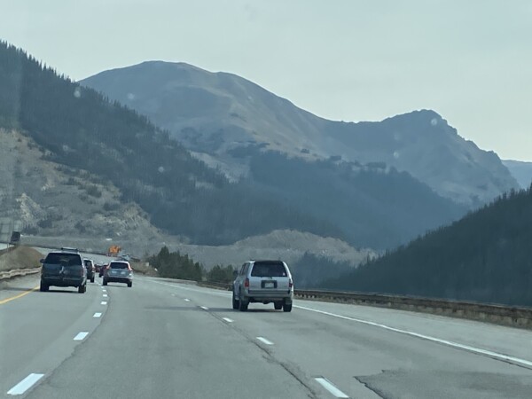
There was some significant UP to be climbed! We filled up with gas in Silverthorne and reset the truck’s fuel-o-meter. Dang… with all the up, we were getting 8 mpg. YIKES! But hey, that’s still 4x better than the boat, right? (hee-hee). So in less than 10 miles, we made it to the top of the Rockies – the Continental Divide – the Eisenhower-Johnson Memorial Tunnel. Elevation 11,183 according to my app!

This tunnel was built in the 1970’s, is 1.6 miles long and goes downhill when traveling east.
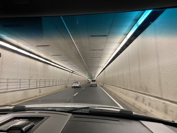
When you come out on the east end, you continue going downhill for the next 60 miles to Denver (and for the next few hundred miles into Kansas.) These are the Rockies!


We had a couple of up hills amidst all of the downhill, but we were up to 24.8mpg! And we could not believe all of the westbound traffic!! Where in the world were all of these cars going west across the mountains!?

We made it down to Denver (that sounds funny, huh?) and traffic wasn’t too bad. Here’s a quick glimpse of downtown.

As soon as we got to the outer beltline on the east of Denver, it became flat farmland. Another 200 miles, and we found Kansas! This is a new state for us…. never been to Kansas before. Let’s hope we don’t end up in Oz!

And we soon saw why the Kansas sign had a sunflower on it. Fields of droopy faced sunflowers. 🌻 ☺️ The sky was pretty hazy, so maybe there wasn’t enough sunshine for them to look up to. They were looking pretty dry, too… so maybe the seeds are ready to harvest?

This was the scenery for a lot of miles. The wind was blowing really hard from the south, so there was a lot of dust was in the air.

Yep – south wind at 25, with gusts to 35. There was no using auto-pilot today! The wind would most certainly blow us right out of the channel! HA! At least strong one-directional wind is not what tornados are made of, so no chance for seeing Oz today. Whew! 🌪

More typical Kansas scenery. Lots of fields and grain silos.

We even saw some active oil rigs!

Soo….. not to be political or start any arguments, this was really just to catch how straight out the flag was in the wind.

This was just a cute old house that I managed to capture. Hey! There’s hills in the background!!

We saw LOTS of fields that looked like this with orangey-reddish blooms. It is sorghum, which is used as a sweetner, as cattle feed, and as ethanol fuel. And.. we saw lots of cows and a stockyard. Heartland beef on the hoof.

Hundreds of windmills were gathering zillions of kilowatts today!

Later in the day as we approached mid-Kansas, there were actually some hills along the way, adding a little bit of interest to the topography.

Tonight we are sleeping in Salina Kansas. Just a spot to stop along the way to break up the 1250 miles between Breckenridge (our last stop for stuff to do) and Frankfort Kentucky (our next stop for stuff to do). And look! We’ve gone downhill a lot today – from a high of 11,183 to 1,219. Wowza!

And yes…. we are breathing much better now! Plus, the humidity is up from the 25% in Breckenridge to 47% daytime humidity here. My skin was really getting dry with the elevation and low humidity. Not saying that I’m ready for the 60+% that we’ll find in Florida, but it is nice to be at an elevation and humidity that isn’t so hard on us old people! Tomorrow is another 500 mile day, through Kansas and Missouri with an overnight stop in Illinois. Kenny dislikes Illinois almost as much as California… but I’m just trying to take the most direct route and not travel more than 500 miles/day. We will go through the cities of Kansas City, St Louis, and Louisville…. hoping to miss any and all protests and riots going on by staying on the Interstate. Crazy times.