Sunday, April 11, 2021.
Weather: Temp: 74/64, Humidity: 99/65%, Top Wind: SW12 mph, Precip: none but dark clouds, Miles Traveled: 68 miles
**********************
This was one of those days when we had to set the alarm to get up early so that we could leave by sunrise. The timing with the tides and current was going to work out perfectly today! We had three major challenges today: a known shallow section about 18 miles from here, another shallow area 14 miles after that, a swift current cut just before Charleston, as well as the current on Ashley River in Charleston. (Yes – the river is tidal influenced, so current actually goes both ways there.) Timing couldn’t have been better. We must have an amazing navigator 😁 (who knows luck when she sees it!). Last loop in 2018, we had to do this stretch in two days due to the tides. I was feeling pretty good about my plan. Captain said he tossed and turned all night, with recurring dreams of being stuck in deep-enough water, but shallow water all around us so that we couldn’t get out! Oh dear. I guess I better not go through this kind of route briefing with him right before bed.🥴
Our escape from the Lady’s Island Marina couldn’t have been easier. We were docked with our bow pointed out, right into the channel! Thank goodness, because the dew point and the temperature were having a love affair, and it took several hours for the windows to clear! Those two can get so steamy! Our sunrise was pretty with just a few clouds as we pulled away.
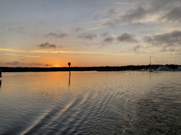
And then the sun peeked up over the edge of the world and I got this cool picture with Ol’ Glory at 7:03am.

Our first challenge was 18 miles out, which was about two hours from Beaufort. High tide at the Ashepoo-Coosaw cut was at 8:54, and our plan was to arrive there by 9:00am so that we’d have more than 6 feet of extra water. And we did! Through the cut, we never saw less than 13’, so we were really happy about that. We also have the fortune of following a very reputable captain’s track. Bob423 has a facebook page for the Atlantic ICW, as well as a website with all kinds of navigational help. He also works closely with Waterway Guide to provide information to ICW mariners. He travels the ICW southbound in the fall, and northbound in the spring. He is diligent about documenting his track and publishing his findings, and making his track available for download. So I downloaded it into our Aquamaps app on Gladys. This is the same app that has all of the most recent USACE depth surveys. Bob’s track overlays that and it give an fantastic image of what’s happening below the boat. Here is a sample from the cut we went through today. Between the coloring from USACE, depth indicated in feet, and Bob423’s blue dotted line track, it makes going through places like this a lot less stressful!

This was at 9:30 as we went through the cut, and the window on the right was almost clear and dry from this mornings dew.

Our next navigational ‘aware and beware’ was Watts cut, which was another 14 miles. I figured that we’d arrive there before 11:00, and should still have a good 5’ of tide water in our favor based on the nearest tide station. Yep – it went well too! The shallowest we saw there was 12’, and that’s when we had to get off track a bit for an oncoming boat. YAHOO!
Here are our uniforms for today… fuzzies on. And even though we were wearing shorts, Captain’s legs were wrapped up in a towel because the wind was coming from behind us and freezing his legs. I finally zipped down the enclosure canvas at the ladder, and that helped a lot. Then the only thing open was his front window, but we had no breeze from the front because the wind outside was actually a tail wind stronger than our motoring speed.

For awhile it looked like it was going to rain but it just got dark. No rain, but it stayed cloudy. This is a typical scene for today – grassy low country! Makes you think of shrimp and grits, or a low-country-boil, or other low country goodness.

At one point we had another Looper boat come out of a creek and pull out ahead of us. I believe they had been at anchor and were now doing the same thing as us…. timing arrival in Charleston for a slack current!

These were some interesting docks… jutting waaay out from land to find deep enough water. I wonder how property taxes are assessed and paid for this kind of water access?

This was our next navigation plan…. hit the Elliott Cut, which is just before getting to Charleston, at slack or near slack tide. Slack current was supposed to be at 3:17. I figured we’d be here around 2:30, and we were! (Captain had slowed us down to try to not get here too early!) We had current for us and against us all day, so on average, my estimate was pretty close. Current was still running in here, pushing us from behind. It is a really narrow spot and the current can run up to 5mph in here. The boats coming toward us were fighting the current. It is not a no-wake zone, because boats do need to maintain control so that the current doesn’t control the boat.

Here is what was happening with Island Girl rafting down the river. Captain pulled back the throttles to a low-wake rpm of 880. Our normal no-throttle idle is about 575 rpm which has us going about 5mph. Our normal cruise speed is around 1250 rpm, which usually gives us about 9mph. We were at 880 rpm, and going 12.2 mph!! Holy whitewater, Batman! There was a curve as we came out of this cut, and Captain had to power into it because we were totally doing a Tokyo Drift. 😳

The cut turned into a wider body of water called Wappoo Creek, so the current slowed down considerably with more area to spread out. Then we emerged into the Ashley River, with Charleston straight ahead. There were a gazillion boats – some at anchor, some moving slow, some moving fast, some with sails, some really tiny…. and the wind was blowing and the current was still flowing.

Our destination was the Harborage as Ashley Marina. All of the slips are privately owned, so slip owners can rent them out on their own, or make them available to the harbormaster to rent out. I had contacted an AGLCA (Looper) member that had posted once that he had a slip available sometimes to Loopers to rent directly from him. His wasn’t available, but he thought his friend’s slip might be, so he gave me Alan’s contact info. Alan said his slip wasn’t available, but he’d check with some clients. (I have no idea what that meant, and I didn’t inquire.). Someone had a slip available that is listed with the marina as a 40’ x 17.5’ slip. Great! And that owner would rent it to us at about half price of what the marina charges. Super! So I got all the info through Alan about this slip, and we made plans to stay for 2-3 nights. Alan said we didn’t need to call the harbormaster on our approach, we could just come to the slip. The current was pretty well settled down, but the wind was blowing harder than we thought. So Captain called the marina and requested some help on the dock. We needed to go up-river, past the City Marina and the Mega-dock, go all the way past the Harborage marina, then do a 180 and go down inside the marina all the way toward the big bridge to the last dock.

This was the bridge at the north end of the marina – we’ve never been up here before.

We turned to go into the marina, and the wind really messed with us!, Captain had to abort and redo our approach into the marina fairway because it was blowing us sideways toward shore. That was a surprise! So he absolutely decided to go into the slip bow first rather than try to get turned around and back in with these conditions. A dock hand was there to catch lines, thank goodness, but ….BIG PROBLEM!! This finger pier is actually only 35’ long, even though the marina indicates that it’s 40’. We are a 40’ boat, with a swim-step and dinghy on the back. But the stern of our 40’ was easily sticking out 5’ from the end of the dock, let alone Stuart! So the stern cleat on the boat was waaay out behind the dock. In the wind and swirling current pushing us away from the dock, we could NOT get the stern to stay on the dock, and we had some real issues getting Island Girl pulled over. The wind really wanted to send her smack into the sailboat next door. YIKES! It was a hair raising nail biting kind of docking because none of the lines were keeping her stern close enough to the dock! The dock hand and I got us as secured as possible, and Captain stayed at the helm to keep nudging the boat to stay somewhat straight in the slip. I managed to get off the boat, the dock hand and I went to the office, I explained why we were in that slip, and we all agreed that it wasn’t going to work for us or for the marina. Fortunately they had a 50’ slip available that they could put us in, right across the dock from where we were. We’d have to pay the full marina rate instead of the Homie-Hookup rate, but I was TOTALLY OK with that!! We just had to untie without mating with the sailboat, and go allllll the way back out of the marina, around and down to the big bridge, and into the new slip. The pink line is our initial approach, the yellow is our reassessment and reassignment. We fit much better here in this 50’ slip, with room to spare! WHEW!!!🙄

This is where we are for the next three nights.

I snapped a couple of pictures after the sunset. This is looking back up the long fairway that we came down. The slip we first tried to be in is just out of the picture on the right, sharing the dock with the sailboat at our bow. Thank goodness that the little sailboat in the slip next to the slip we tried to fit in was a skinny little thing and we didn’t hit her!

Sunset was pretty – looking across the Ashley River.

We are docked almost under a big bridge. It’s noisy, but we sleep with the A/C running, so it’s not terrible. We’re thinking we might be able to get Stuart launched and brought around to the bow of Island Girl to try to clean up her chocolate moostache sometime while we’re here.

Here was our squiggly 68 mile, 8 hour day. It shows that the red lines are where we went between 10-15 mph. We didn’t try to, but those are the places where the current was helping us along. In fact, Captain dropped our rpm for at least an hour before we got to Elliott Cut, trying to help us get there later…. but the current just kept pulling us along!

We don’t have anything specific planned to do here in Charleston. We have some packages that should arrive tomorrow, and a few boat projects. Like Savannah, we always enjoy Charleston, but we are a long walk from town, so we’ll see what we come up with for adventures. I did find a real doughnut station that might convince Kenny that he needs to walk a bit. 😉🍩
Happy belated birthday, Easter and travels! Just read 10 days, and impressed with your adventures!
Thanks PS!!